
I recently booked a very last minute road trip to Yosemite National Park to witness the splendor of the raging waterfalls. Reservations are not needed currently. This summer, due to the record-setting snowpack over the winter, you get a rare opportunity to see the waterfalls at this national park like never before! Yosemite National Park is also home to one of the tallest waterfalls in the world and I really wanted to see these falls in its full force. This is the best year to travel to Yosemite. In this blog, I’m going to share tips on things to do in Yosemite National Park, the best hikes to do, and where to stay and what to eat.
The Magic of Yosemite National Park
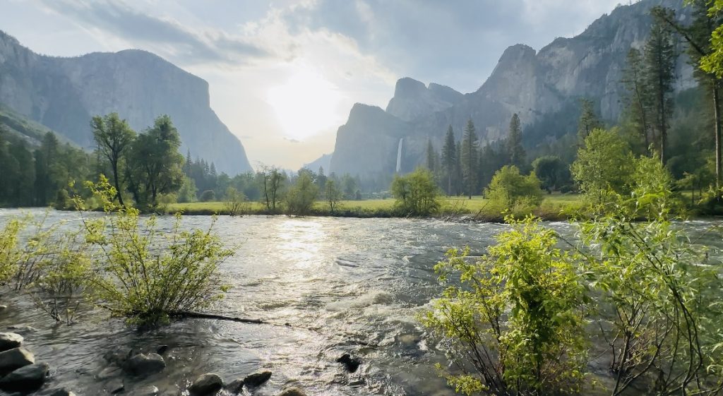
Yosemite National Park is in the heart of California’s Sierra Nevada Mountains and is a UNESCO World Heritage Site known for its towering granite cliffs, ancient sequoia groves, diverse wildlife, and, of course, its iconic waterfalls. As we speak, the park has transformed into a mesmerizing paradise, visiting now means there are many things to do in Yosemite National Park, including seeing the waterfalls in their peak intensity after a historic snowfall.
Directions to Yosemite National Park
Closest Airports
The closest airport to Yosemite National Park is Fresno Yosemite International Airport (FAT). Other airports are Oakland International, Sacramento International, San Jose International, San Francisco International and Mammoth Yosemite Airport. Travelers that fly to California can rent a car in San Francisco (3.5 hours away) or Sacramento (3 hours away). The public roads are maintained year-round—except for the eastern entrance on Tioga Road (Highway 120 through the park). As of June 10, 2023, Highway 120 is now open. But be sure to call the National Park Service information line at 209.372.0200 or visit the National Park Service road conditions page for the latest updates.
Coming from SF or Sacramento?
If you’re coming from San Francisco or Sacramento you’ll want to take Highway 120 into the park. This route passes through the lovely towns of Oakdale (good for groceries and gas), Buck Meadows and Groveland (you can grab food/gas/water here and check out the oldest saloon in California). Highway 120 is mostly straight or gently curving, except for the 8 mile Priest Grade ascent which will gain over 1,000 feet of elevation in 8.5 miles.
Why take Highway 140?
Typically if the higher elevations roads like Highway 41 and 120 are closed, you can take 140 into the park. 140 also takes you through the historic town of Mariposa and is also known as the All-Weather Highway, since it’s at a lower elevation and remains snow-free more often.
Coming from LA?
If you’re coming from LA you would take CA-99 and CA-41 to Yosemite National Park. From San Jose you would take 152E and 140E and enter through El Portal into the Yosemite Valley.
The Impact of Record Snow Melt
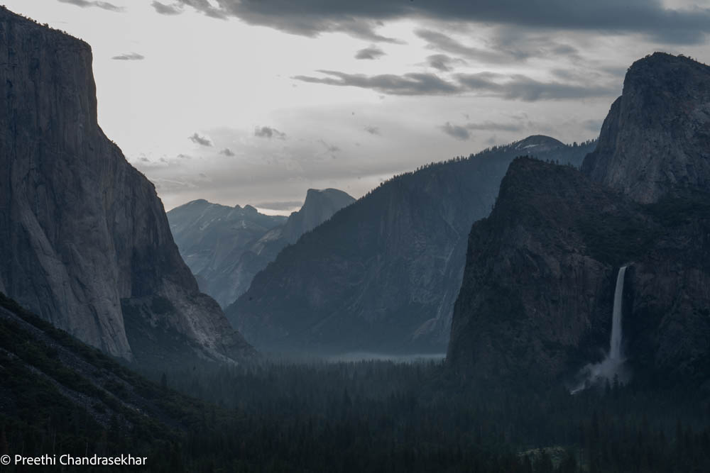
So what exactly happened this past winter that’s making everyone want to travel to Yosemite right now? The winter basically brought record-breaking snowfall to the Sierra Nevada, resulting in an unprecedented snowpack. And with the summer sun coming out, the snow is melting, giving rise to a dramatic surge in the water flow. This has created a captivating display of roaring waterfalls, where cascades of crystal-clear water plunge down the rugged cliffs, creating misty rainbows and a symphony of sounds. Not to mention the entire park is more lush and green and feels like you’re in Rivendell.
How to Plan Your Trip to Yosemite
Getting inside the park
All park entrances are open 24 hours a day and do NOT require any reservations currently. The cost to enter per vehicle is $35 (valid for 7 consecutive days) or $80 for an annual pass. I purchased my National Parks Pass for the year so I can enter any national park this year across the country. This cost me $80. If you’re entering the park early morning or late evening, and the kiosks at the entrances are unstaffed, please pay on your way out, or pay in advance.
There are five main entrances to the park: Hetch Hetchy (takes you to another side of the park and to the Wapama Falls), Big Oak Flat entrance (on Highway 120 entering from the Bay Area), Arch Rock entrance (Hwy 580 – 205 – 140 from SF through El Portal Road), Highway 41 (South Entrance, when you come from LA/SD) and Tioga Pass Entrance (Highway 120). NOTE: Glacier Point Road will be open weekends only starting July 1 – July 4 from 6am-10pm and July 8-9 from 6am-10pm. It will be open 7 days per week, 24 hours per day starting July 15. Expect 30 minute delays, Mon-Fri, 6am to 9pm. Tioga road will not be open for the July 4th holiday weekend.
Accommodations
So what are the things to do in Yosemite National Park? There are plenty of things to do, but first look for accommodations. This might dictate when you get into the valley to start enjoying the park. Choose from widely varying accommodations including resorts, vacation rental cabins, bed and breakfasts as well as camping.
Camping
There are 13 popular campgrounds and reservations are available at different times depending on the campground. All non-lottery reservations are released at 7 am Pacific time and sell out within minutes. Yosemite Creek, Porcupine Flat, Tamarack Flat, and White Wolf campground reservations are released two weeks in advance on a rolling daily window (i.e., 14 days in advance of arrival date). Camp 4 reservations are released one week in advance on a rolling daily window (i.e., 7 days in advance of arrival date). Reservations required May 21 through September 30, 2023.
-
- Visit www.recreation.gov (recommended)
-
- 877/444-6777
(or 877/833-6777 for TDD)
(or 518/885-3639 from outside the US & Canada)
- 877/444-6777
Little known/free campsites
#1 Lumdsen Campground
GPS: 37.838203, -120.047417. (209) 962-7825.
Lumsden Campground is a low elevation campground surrounded by forests of pine and oak next to the Tuolumne Wild & Scenic River just off the side of Forest Route 1N01. Lumsden Campground is open year round on a first come – first served basis. Each campsite has a picnic table and a campfire pit with a grill. The campground also has a vault toilet for campers, but no drinking water. Treating the river water before drinking is recommended.
#2 South Fork Campground
GPS: 37.84° N, 120.046° W. (209) 962-7825.
South Fork Campground is a low elevation campground surrounded by forests of pine and oak and is open year round on a first come – first served basis and each campsite has a picnic table/campfire pit with grill. It has a vault toilet but no drinking water, treat the river water before drinking.
#3 Cherry Valley Campground
GPS: 37.981° N, 119.921° W. (209) 962-7825).
Cherry Lake is the largest lake in Stanislaus National Forest. Open year-round, visitors can enjoy hiking, fishing, boating and swimming. Camping is permitted around the lake at least 100 feet away from the high water mark. No access to drinking water, treat the river water before drinking.
#4 Lumsden Bridge Camground
GPS: 37.848259, -120.03112. (209) 962-7825
Lumsden Bridge Campground is a low elevation campground surrounded by forests of pine and oak and is located off the side of Forest Route 1N01. It is the third campground encountered along Forest Route 1N01, following Lumsden Campground and South Fork campground. The Tuolumne River provides access to untreated drinking water as well as fishing and boating. Lumsden Bridge Campground is open year-round on a first come – first served basis.
#5 Jerseydale Campground
GPS: 37.545639, -119.838707. (559) 877-2218
Mariposa
Mariposa County offers everything between “roughing it” and traveling in VIP style. Popular places to stay include Curry Village, Evergreen Lodge, Rush Creek Lodge, Yosemite View Lodge, and the picturesque Ahwahnee Hotel INSIDE the park. Decide if you want to stay in hotels inside the park or in hotels near Yosemite National Park. I found a last minute hotel room in Rush Creek Lodge to split with a friend.
How to choose where to stay?
This depends on which location you are entering/exiting from.
Big Oak Flat Entrance Highway 120:
You’ll pass the town of Sonora (look for hotels here), you’ll pass by Groveland so you can stop here for gas/food/groceries and discover live outdoor music during the summer at the historic Groveland Hotel patio and daily wine tastings at the historic Hotel Charlotte, both downtown. And you cannot pass through town without stopping at the Iron Door Saloon, the oldest continuously operating saloon in the state. The legendary saloon opened its doors in 1852. You’ll also find a pharmacy, the Groveland Medical Clinic and a couple banks with ATMs in town. Check Rush Creek Lodge which is 5 minutes from the park entrance and 45 minutes to the Yosemite Valley floor.
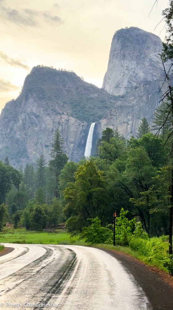
NOTE: If you’re going straight to Yosemite Valley from Highway 120 Bay Area, you will be entering into the one way Southside Drive and your first glimpse of waterfalls will be the Bridalveil Fall on your right. You can park on the road (on the left) if spots are still available (if you’re getting into the valley before 8am) to take in this view.
Arch Rock Entrance Highway 140:
When you enter the park through the Arch Rock Entrance, your road turns into El Portal Road, which leads you in Yosemite Valley. The closest town to Yosemite is El Portal, which has gas available 24 hours a day with a credit card. There’s also the El Portal Market, a picnic area and campgrounds. To the west of El Portal is Midpines and Mariposa. Mariposa is the largest of the three with the most services. Midpines is 10 miles from Mariposa and 25 miles from Yosemite Valley. You’ll find some swimming holes in upper Bear Creek, and the Merced River offers great rafting, swimming and fishing opportunities. There is a collection of cabins, hotels and bed and breakfasts in Midpines. Look for hotels here.
Mariposa
But if you are looking for some nightlife and old-town charm, check out Mariposa and its historic downtown. Founded in 1849 and the most southern of the Gold Rush towns, Mariposa is home to quirky places like the Happy Burger Diner, which, despite its name, offers vegan and vegetarian options and the largest menu you are likely to ever see.
South Entrance – Highway 41
The closest town to the park entrance on this route is Fish Camp, a tiny town that has several different types of lodging and some really unusual activities to round out your Yosemite adventure. There’s also Tenaya at Yosemite, a gorgeous 350-room resort with a variety of lodging options from cabins and cottages to lodge rooms. Take a dip in one of three pools or dine at an on-site restaurant. If you have the time don’t miss an epic historic train ride through the Sierras. I talk about it here in the section labeled Day 5. Thirteen miles from Fish Camp is the more bustling town of Oakhurst, which has national chain hotels and restaurants for those looking for familiar sights. It has art galleries, bookstores and gold panning activities.
Tioga Pass Entrance (Highway 120):
Going to Yosemite from the Lake Tahoe area, Las Vegas or Death Valley from May through October? If so, head to Yosemite from the eastern side of the park via the Tioga Pass Entrance. Reno is about 140 miles and about a 3-hour drive away from this entrance. Las Vegas is a little less than a 6-hour drive. Sandwiched between the park and Mono Basin National Forest Scenic Area, Lee Vining is a charming, tiny town and the closest town to this entrance. Home to a little more than 200 residents, you won’t find a Holiday Inn or Denny’s here. This is where locally owned businesses thrive. You’ll find a collection of restaurants and lodges to stay.
How many days in the park?
Then decide how many days you have to spend in this park. Based on that you can decide what to see. Below I have listed what you can see in 24-48 hours so use this to help plan your trip. I stayed for 24 hours and saw most (not all) of the sights listed below + hiked Wapama Falls at Hetch Hetchy, Lower Yosemite Falls and the Mist Trail (halfway up to Vernal Falls only).
Please be aware of the following as you visit the park:
-
- Avoid feeding wildlife
-
- Dispose of trash properly (leave no trace)
-
- Drive carefully and watch for bears
-
- Consider taking public transportation whenever possible
-
- Keep your distance from animals
-
- Avoid moving sticks and rocks in rivers
-
- Book direct to support local businesses
-
- Consider voluntourism
Are Dogs Allowed in Yosemite
When you travel to Yosemite, you’ll notice certain areas such as campgrounds and picnic areas are very dog-friendly. On the other hand, many hiking trails and most shuttle buses do not allow pets for their safety. Also, many accommodations including all in-park hotels prohibit pets inside the property’s buildings. Before you plan your trip, check out our Dog Lover’s Itinerary for a better sense of how you and your pup can have a great time in Mariposa County.
Water Safety
Rivers and creeks in Yosemite are at or near flood stage. Stay out of rivers and creeks. Stay away from rock adjacent to rivers; wet rock is extremely slick. Do not cross bridges that have water flowing over them.
Yosemite Attractions – When to enter/What to see
Early morning:
If you’re driving into the park from the Bay Area Highway 120, and you’re coming directly into the park, follow directions for the Yosemite Valley. Driving through the valley is a 30 minute loop and is one of the most scenic drives in California. But chances are you’ll want to stop at various spots along the way and this is a one way drive from Southside Drive to Northside Drive. If you get into the park between 6am-7am, you can drive through the park and stop at the various parking lots or find street parking. But the parking lots fill between 8am-9am especially on weekends and it may not be easy to drive from parking lot to parking lot as you try to cover all the spots that you may want to see within the valley. And yes a lot of the spots require you to stop and walk a little bit.
Parking vs Shuttles:
I recommend you head into the park by 7am, park at either Curry Village parking lot, Yosemite Village parking lot, or in the parking lot near the Chapel (the parking lot can be closed sometimes), or even park on the street on Southside drive and then be prepared to walk the Valley loop on foot OR take the free shuttle OR cycle around the park. This loop trail is approximately a 11 mile trail that goes around the Valley floor. If you don’t have the time to walk that loop, then park in one of the suggested lots above and plan out your shuttle stops. Shuttles WILL be crowded, people aren’t getting down at all the stops and you may need to wait your turn for over an hour. The free green shuttle route arrives every 12-22 minutes from 7am to 10pm and takes you to the following stops that may be of interest:
-
- Stop #6: Lower Yosemite Fall hike trailhead
-
- Stop #7: Yosemite Valley Lodge/Upper Yosemite Falls trailhead Parking Lot
-
- Stop #8: El Capitan Picnic Area
-
- Stop #9: El Capitan Meadow
-
- Stop #10: Cathedral Beach (walk to Swinging Bridge from here)
-
- Stop #11: Four Mile Trail
-
- Stop #16: Happy Isles (Mist Trail)
-
- Stop #17: Mirror Lake
-
- Stop #1: Yosemite Village Parking
-
- Stop # 14 and 19 for Curry Village Eastbound & Westbound
What to do in Yosemite National Park
Yosemite Hiking Trails
There are many things to do in Yosemite National Park, one of them being exploring the park via its many hiking trails. Here are some of the more popular trails right now.
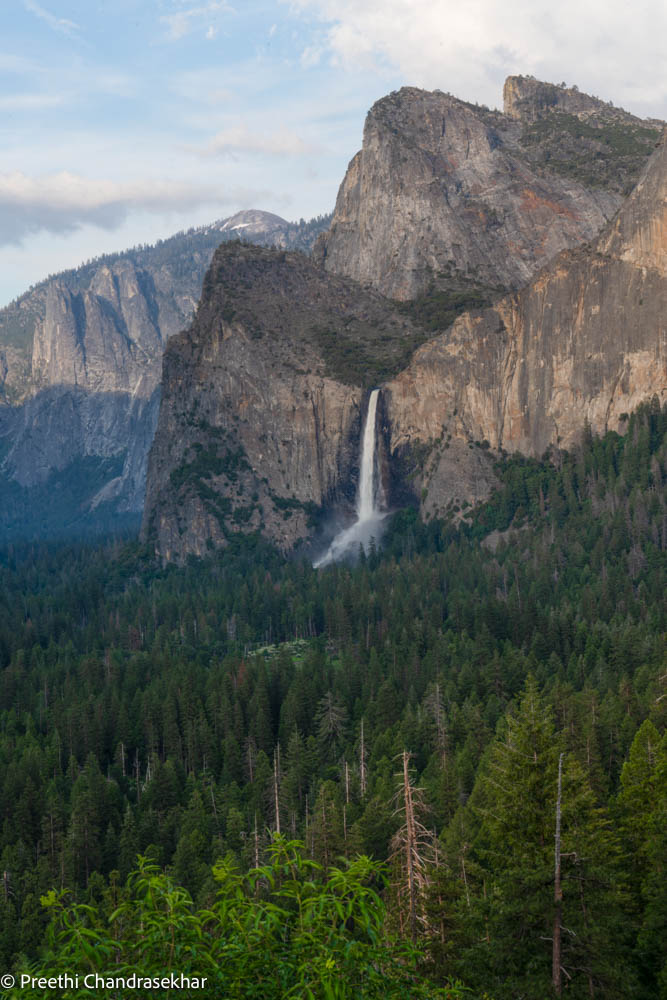
Bridalveil Falls Trail
One of the easiest things to do in Yosemite National Park is to see the Bridalveil Falls. This is an easy trail that begins at the Bridalveil Falls parking area. Parking is available at the trailhead, accessible from the Wawona Road (continuation of Highway 41) or Southside Drive. If you choose to park along Southside Drive, when getting out of your vehicle, watch for traffic and be cautious opening car doors and crossing the road. The trail is 0.5mi round trip from the parking lot with an elevation gain of 80 ft.
If you go from Southside drive, then you’ll find parking on either side of the road with a different trail option. This trail is a bit longer—an additional 0.25 miles (0.4 km), crosses Bridalveil Creek, and showcases different views of Bridalveil Fall as you approach the main parking area.
As of 6/10, the official trail was closed, but you can still get pretty close to the falls by walking to the base of the falls from Southside drive. The trail has been closed due to the Bridalveil Fall Rehabilitation Project.
Lower Yosemite Fall Trail
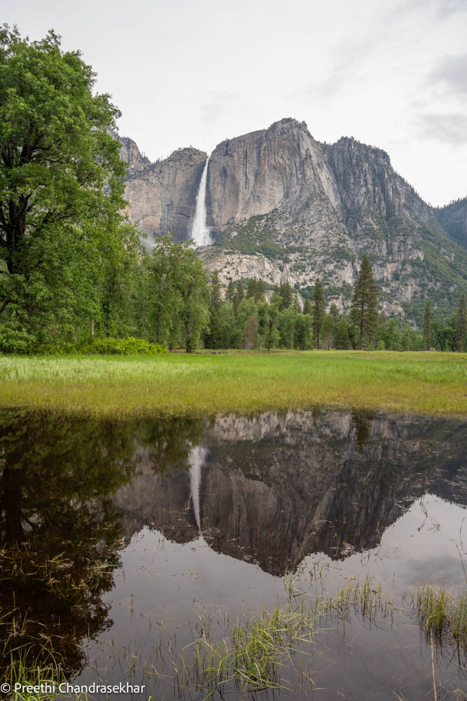
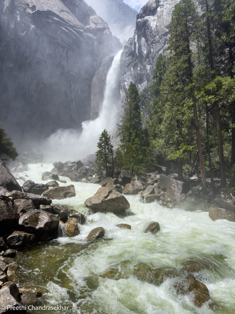
Hiking Lower Yosemite Falls is an easy hike and amongst the best things to do in Yosemite National Park right now. This trail is a 1 mi round trip loop with a 50 ft elevation gain and is one of the best trails to experience in the park right now. This is part of North America’s tallest waterfall loop. Begin at the lower Yosemite Fall Trailhead (view map for nearest shuttle stop). Lower Yosemite Fall is the final 320-foot drop of the Yosemite Falls. Deafening in spring and early summer (till mid-July) when the waterfall peaks in volume, you can expect to get sprayed with water when standing on the footbridge near its base. Right now you will get quite wet as of 6/10/23 due to the high water levels due to the snow melt.
If walking from the Valley Visitor center, follow the bicycle path to Lower Yosemite Fall shuttle stop and begin the trail. Consider walking the loop in a clockwise direction for best views of Yosemite Falls. If you found parking near the Chapel, then walk across the street, cross the bridge and over to the falls. You can use AllTrails (Download trail maps offline) to get started on this trail. Use my code: Preethi to get your first month free so you can try out the app if you don’t already use it.
Parking is not available at the trailhead. Parking is available at the Yosemite Village and Yosemite Falls parking areas.
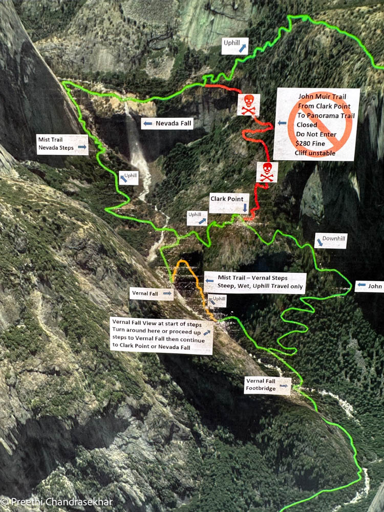
Vernal Falls and Nevada Falls Loop
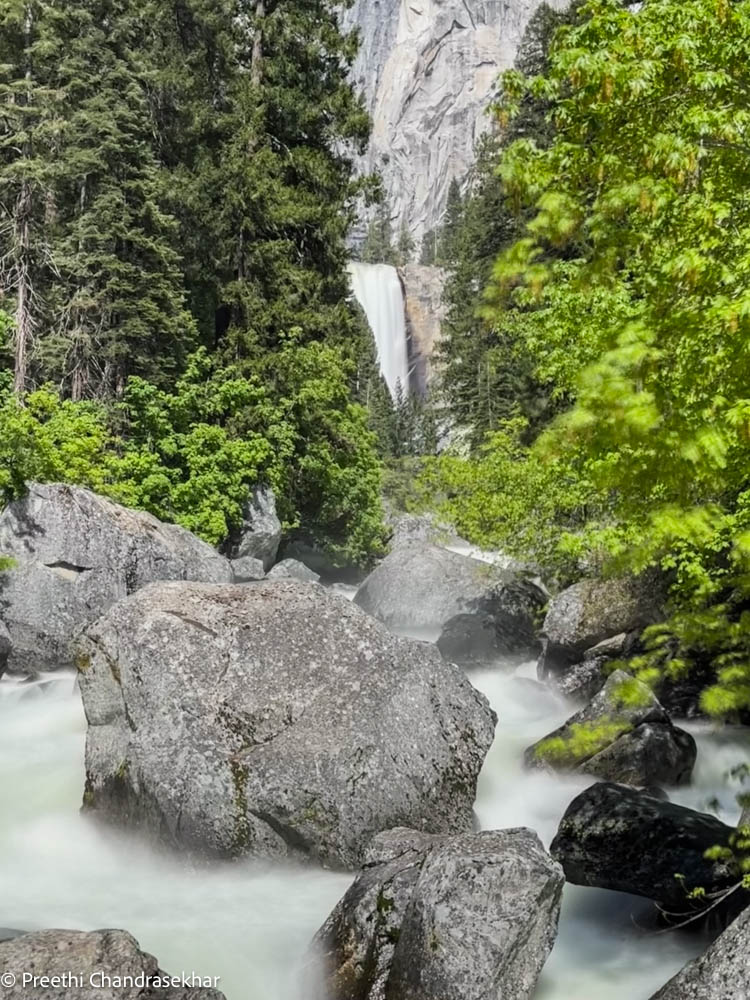
Add this to the list of things to do in Yosemite because this might be the BEST hike to do right now because of how full these falls are. Depending on how far you hike on this trail, it can be from 1.6mi to 8mi round trip. Elevation gain is 400ft to 2000ft. I took the shuttle to stop #16 and walked over to the Mist Trail trailhead. From here I walked over to the Vernal footbridge at 0.8mi with an elevation gain of 400ft. You don’t get sprayed here and you’ll get a good view of Vernal falls flowing downhill as seen in the pic below.
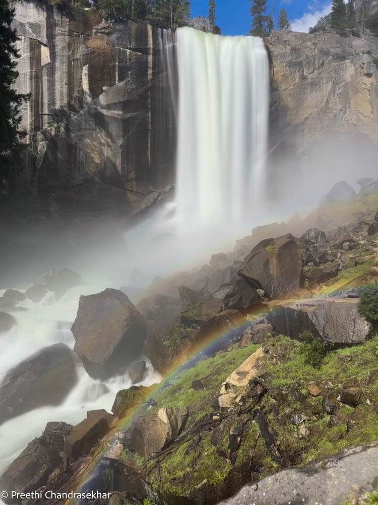
About 0.2 miles beyond the bridge, there’s a sign/fork in the trail where the Mist Trail and the John Muir Trail diverge. To go directly to the top of Vernal Fall, go left and follow the Mist Trail 0.3 miles up a steep granite stairway of over 600 steps. Right now these steps are slippery and there’s a tremendous amount of waterfall spray which is refreshing, but yes you will get wet! The views of Vernal Fall all along this stretch of trail is delightful and you may even be able to see a rainbow in the spray of the fall if the sun is out, as shown in the second pic below! At the top of Vernal Fall, you can experience jaw-dropping views straight down the length of the 317-foot waterfall (please don’t cross the railings and use extreme caution while you’re near any flowing water or wet rock in this area).
From the top, you can: choose to turn around and head back the way you came; continue up to the next junction (about 0.2 miles) and take the longer route back via the John Muir Trail; OR continue uphill on the Mist Trail to the top of Nevada Fall. If you choose to continue on the Mist Trail, shortly beyond Vernal Fall, you will pass by Emerald Pool and Silver Apron. Both of these look may look inviting on a hot summer’s day, but it is illegal and dangerous to swim here due to the extremely hazardous current.
Continuing along the Mist Trail, you’ll experience another 1.5 miles of steep, rocky switchbacks in order to reach Nevada Fall. Crashing down 594 feet, this thunderous waterfall is magnificent. At the top of the climb, head right to reach the footbridge that crosses the Merced River above the fall, allowing you a closer view of it. Use extreme caution while you’re near any flowing water or wet rock in this area.
From here, you can either return down the Mist Trail, or continue over the bridge to the John Muir Trail for an alternate route back to Yosemite Valley. If you choose the John Muir Trail, you will enjoy different scenery, with great views of Liberty Cap and different views of Nevada Fall. The John Muir Trail is longer—approximately 4 miles one-way compared to the Mist Trail’s 2.5 miles—so plan accordingly. See the map below if this is confusing.
Four Mile Trail
This hike is a strenuous hike and is 4.8mi one way with a 3200 ft elevation gain. The Four Mile Trailhead is along Southside Drive in Yosemite Valley. This area is also serviced by the free Valleywide Shuttle (stop #11). Spectacular views of Yosemite Valley, El Capitan, Yosemite Falls, and, eventually, Half Dome await those willing to tackle this strenuous trail. And oh this hike ends at the famous Glacier Point. You then come back the same way.
Upper Yosemite Falls Trail
This is a 7.2 mi round trip hike with elevation gain of 2700 ft. The Yosemite Falls Trail leads to the top of North America’s tallest waterfall, which rises 2,425 feet above the Valley floor. This is a strenuous hike with several switchbacks. If you make the one-mile, 1,000 foot climb (via dozens of switchbacks) to Columbia Rock, you will be rewarded with spectacular views of Yosemite Valley, Half Dome, and Sentinel Rock. From there, it is worth the time and energy to hike another 0.5 miles (some of which is actually downhill!) to get a stunning view of Upper Yosemite Fall. You can either turn around here or continue to the top for spectacular views of Half dome and the valley. This hike is rated difficult by Alltrails and I agree.
TIP: Take more water than you think you need. I took 2.5L and still ran out. You will get sprayed a bit by the mist but shorts and t shirt is totally doable as it’s super hot right now in June and July. Take hiking poles which can be super helpful on the uphill switchbacks and on the way back down. Wear good hiking boots with traction as you’ll be hiking on rocks and steps. My calves are still sore 48 hours after completing this hike so make sure you foam roll, and stretch before and after the hike! It may get windy and chilly at the top so be sure to carry layers. Have a solid real breakfast and carry an actual lunch. It took me a total of 7 hours to get back down.
Mirror Lake
The trailhead to Mirror Lake is right by the Mist Trail trailhead for Vernal/Nevada Falls so get down at shuttle stop #17. . This trail is about 2 miles round trip to the lake and back so a total of 5 miles around the lake. The first mile of this trail is a paved service road that leads directly to Mirror Lake. You may access the loop trail from the end of the paved path. The loop follows Tenaya Creek beyond the lake, and crosses two bridges after the Snow Creek Trail junction before returning past Mirror Lake on the south side of Tenaya Canyon.
Best Views in Yosemite – Without Hiking!
If you have only 1-2 days and let’s say you’ve come into your hotel the night before and you’re waking up early the next day morning to drive into the park for sunrise during your Day 1, then this is how I’d organize your trip to ensure you see the most scenic views (save all the hiking trails for Day 2 morning after sunrise):
-
- Tunnel View: Use Google Maps and enter in Tunnel View. There is a parking lot here that you can park at. Make sure to check sunrise times. For June, it should be about 6:30am. Once you have your fill of Tunnel View which will give you El Capitan, Half Dome and Bridalveil Fall views, nav over to Bridalveil Fall on Southside Drive on the Valley floor.
-
- Bridalveil Falls: The Bridalveil Falls will be the first thing you see on the right as you enter the valley and if you’re in before 8am/9am, you can park on the left side on the road and gaze at these falls or even walk a little closer to it (as the official trail is closed right now). Next you’ll want to drive over to the Cathedral Beach parking (assuming it’s still around 9am you should get parking here).
-
- Cathedral Beach: There are fantastic reflections here of El Capitan and then the Three Brothers to the East. Depending on what time it is, you may want to leave your car at Cathedral Beach and then just walk to Swinging Bridge. Most of the access to Cathedral Beach as of 6/27/2023 is still flooded so you may not get clear reflection shots.
-
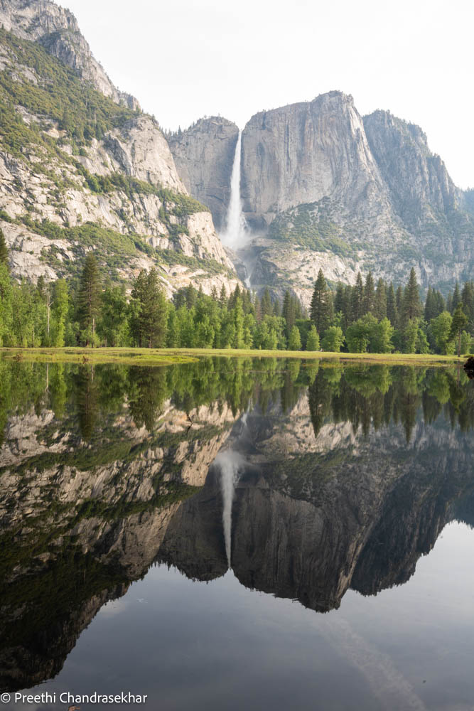
- Swinging Bridge Reflections: As you walk past Cathedral Bridge, you’re going to come to the Swinging Bridge area. There’s an actual bridge you can go explore (no it’s not swinging anymore) and you will see more reflections of Yosemite Falls as more of the meadows here are submerged under water. Once you’ve enjoyed the views here keep walking on the Valley floor till you reach the chapel. You’ll see more breathtaking reflections of Yosemite Falls to your left on this stroll. These areas are the best spots to get reflection photos of the Yosemite Falls.
-
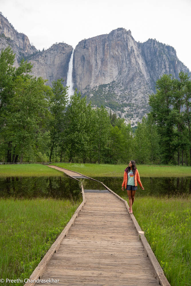
- Boardwalk View of Yosemite Falls: Before you come to the chapel, you will see the boardwalk on the left. Some part of the boardwalk is currently submerged as you can see in the photo below, but it’s still a breathtaking view of the boardwalk + Yosemite Falls.
-
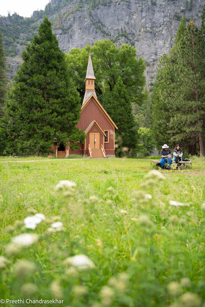
- Chapel: This chapel location (with the mountain framed behind it) and usually with flowers blooming in the foreground, takes me back to scenes in Switzerland/Italy. Take some shots and then head over to see Yosemite Falls.
-
- Yosemite Falls: Once you’re done taking in the Chapel views, cross the street or use AllTrails to help you get to Yosemite Falls. You can literally just walk down until you see the Falls and this view is breathtaking by itself. If you want a closer look (and the possibility of getting wet) then hike up to the footbridge (See my trail description above in the Hiking section).
-
- Sentinel Bridge: Once you finish the Falls, walk over to the Sentinel Bridge to get reflections of Half Dome from the bridge assuming the water is still. This is also a fantastic spot for sunset as the light hits Half Dome in a spectacular way.
-
- Curry Village: Grab a bite to eat here before continuing your exploration. You’re almost done.
-
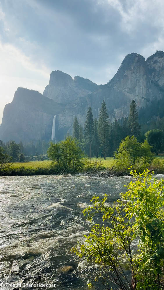
- Valley View: You’ll need your car for this one. Take the shuttle back to the Cathedral Beach parking lot and take your car to Valley View. You are now leaving the Southside drive and looping onto Northside drive toward Valley View. The Valley View has a very small parking lot but it’s not crowded most of the times so you can probably get a spot pretty easily. Here you are unlikely to get any reflections right now because of the flowing Merced River, but it’s a fantastic view of El Capitan on the left, Sentinel Rock, Cathedral Rocks, and Bridalveil Falls gushing down. Oh and the Merced River is raging right now so the sounds and views here especially magnificent at sunrise (you could also see this right after Tunnel View in the morning OR save Valley View for Day 2 morning at sunrise in case you don’t find parking).
- Hikes: Choose from the hikes in the Hiking section above for Day 2, after you’ve seen Valley View at sunrise perhaps.
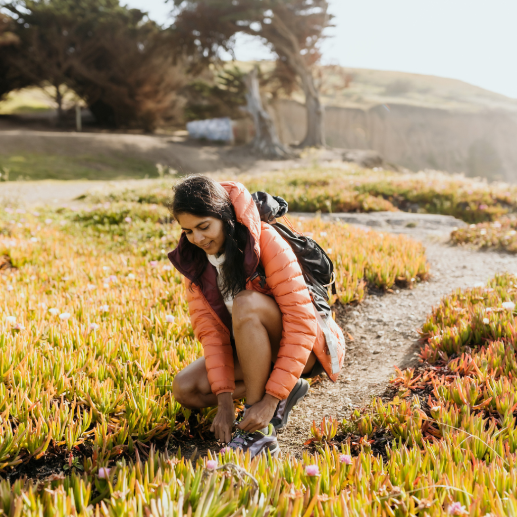
Outdoors Gear to wear in Yosemite National Park
Depending on what you want to hike, I highly recommend sturdy hiking boots with good traction for stability on the rocky and now slippery terrain. The Moab 3 GTX is my current favorite over the Moab 2 because of its improved factory insole, a more cushioned midsole, stickier Vibram soles (better traction), and more recycled content. Use my discount code if you want a pair of sturdy hiking boots: MHC_TRAILBLAZER20_Preethi.
I recommend the NorthFace rain proof shell if you are doing the waterfall hikes so you can stay dry. The pants also come in handy if you want to protect your lower body. The North Face pants and jacket have kept me dry for the past 10 years on many a wet hike. While the mist is refreshing, if you get completely soaked, and the weather is not quite warm yet, then you’ll feel miserable after a while so maybe bring a change of clothes in your backpack. NOTE: As an Amazon Associate I earn from qualifying purchases.
Hotels near Yosemite National Park
The number one question on everyone’s minds is where to stay since every hotel seems to be booked right now through summer. For lodging inside the park, check here. Tip: For the Ahwahnee Hotel, check for cancellations 7 days prior to the date you want to go.
For places outside the park and in nearby towns, check here. I stayed at Rush Creek Lodge which was about 45 minutes from the valley because I couldn’t find accommodations inside the park. Rush Creek Lodge is on Highway 120 from San Francisco and is about 5 minutes before the park entrance and 45 minutes to the Yosemite Valley Loop drive (Southside drive to Northside drive).
Camera Gear
Everyone’s always asking me what I take my pics with. I use my iphone14 Pro for videos and my Sony A7RIII to take photos. I like the Sigma 24-70mm lens and use this most frequently as my travel lens as it’s light and versatile. These pics were taken with the 24-70mm lens. For close up shots of the waterfalls over at Tunnel View, I used my 70-300mm lens which I love for compression shots.
Conclusion
Weekends are packed right now, as everyone wants to travel to Yosemite to see it in its full glory after the record snow this past winter. I highly recommend you visit during weekdays, otherwise be prepared for long lines to enter the park. Download the area map of Yosemite on your phone for offline use to help with navigation as the park is famous for not having great cell reception in some areas. Get the AllTrails app (Free for 1 month with my code: Preethi) and download the hiking trails for offline use as not all the trails are well marked, and it’s easy to go off trail in some of the hikes. Stay safe, recreate responsibly, pack out all your trash and have a great time. Don’t throw toilet paper on the trails, you need to pack it out in a ziplock bag or use the Kula cloth. Above all be patient and kind to each other. Enjoy!

26 Responses
The blog was awesome…very detailed and all you need at one place before hopping on a trip!!
Yay so happy to hear that, thank you!!
This is what I need for my upcoming Yosemite trip. Thanks Preethi.
Amazing, so glad to hear it, thank you for taking the time to read/comments!
Such a well written blog. Thank you Peeps, we have everything right here for our upcoming trip.
Amazing, have a fantastic trip!
So detailed! Thank you! Love following you! Pictures are fantastic!
Thank you so much, I really appreciate that!!
Thank you so much for sharing.
Hope it helps 🙂
Great info on Yosemite, thank you so helpful.
Thank you so much!
Amazing..love the detail!
Thank you!
Loved the details and specially tips on working around the parking situation. We are visiting next week with parents and kids, and were really nervous after hearing the traffic nightmare inside the park. But, your blog gives me hope 🙂
How was it?! Yes traffic is bad but getting in early by 6-7am is the key and shuttles ARE going to be packed.
Thanks for the info.I’m taking your advice for our July Yosemite trip.
Thanks Preethi. This is great and very helpful. Looking forward to our trip this weekend.
I’m so glad, have a wonderful time!
Fantastic, have a wonderful time!!
I just got back from a 2 day Yosemite trip and this blog helped me a lot in planning my trip. One thing to add from my experience is, if you can bike, i would highly recommend getting a rental bike to get around the valley as the shuttles were packed and about 2-3 hours go away waiting for the shuttles. Again, thanks Preethi for this highly informative blog!
Amazing, agree, have updated to add biking as a more viable option – the shuttles take forever! So glad you were able to experience Yosemite this summer!
Super informative! Cheers and big thank you!
Yay happy to hear that!!!
do you have a day to day planner. of the way you did the trails and stuff? like 1st, 2nd, 3rd, with the shuttle stops you did. I see bikes is a good option but if you bike to a certian stop is there places to park you bikes and should we be worried someone to steal them?
No I don’t think you’ll have to worry about someone stealing your bikes because the bikes themselves aren’t that great and all look alike (if you’re bringing your personal bike bring a lock) – most of the places have a bike rack so that shouldn’t be a problem. Call Curry Village’s recreation center 209.372.8323 and make sure of how the bike rental works – but it’s a great option to bike, park and ride a trail. It’s first come first serve so you won’t be able to reserve a bike ahead of time. In this blog I have broken it down in the sections below on how I navigated the park but I’ll work on a day to day planner!