Warning
This project is being replaced by Live Cloud Maps and will stop being updated soon. Please update any image URLs you're using to point to the new project.

This project creates and hosts daily cloud maps based on NASA data for use in 3D modelling software like Blender or Xplanet, or in 2D graphics.
TL;DR: If you need a high-res greyscale almost-live cloud map, use this URL:
https://matteason.github.io/daily-cloud-maps/8192x4096-clouds.jpg
If you have any feedback you can raise an issue, start a discussion or tweet me (@MattEason)
If you find this project useful and you're feeling spendy, you can support me on Ko-Fi:

A rendering of Earth using images generated by this project
- Frequency & availability
- Available images
- Limitations
- Licence & attribution
- Info for nerds (how the maps are generated)
Images are updated once a day. Each day's images are published to GitHub Pages, so if you configure your software to
use https://matteason.github.io/daily-cloud-maps/[FILENAME] you'll always stay up-to-date.
You can download historic images from this project's Releases, or
https://github.com/matteason/daily-cloud-maps/releases/download/[YYYY-MM-DD]/[FILENAME] - for example,
https://github.com/matteason/daily-cloud-maps/releases/download/2022-07-27/8192x4096-clouds.jpg.
I can't guarantee the availability of any particular image; source data may not be available for a particular day if there's an issue with the satellites. I may also need to eventually delete historic images on a rolling basis if GitHub get cross with how much space they take up, so keep your own copy of anything important. If that might affect you, please watch this repo's Issues and I'll let you know if that happens.
GitHub allows CORS on Pages, so you can use the latest daily images directly in JavaScript - for example, in a three.js TextureLoader.
Unfortunately, because GitHub doesn't allow CORS on release assets you won't be able to use the historic images directly in JavaScript. You can either run a server-side process to download the image and serve it to your JavaScript, or find a CORS proxy that will do that and add the Access-Control-Allow-Origin: * header for you.
The following images are created daily. All images are available in four resolutions; replace [W]x[H] in the filenames below with one of 8192x4096, 4096x2048, 2048x1024 or 1024x512
The images shown are the latest images generated and refresh every day.

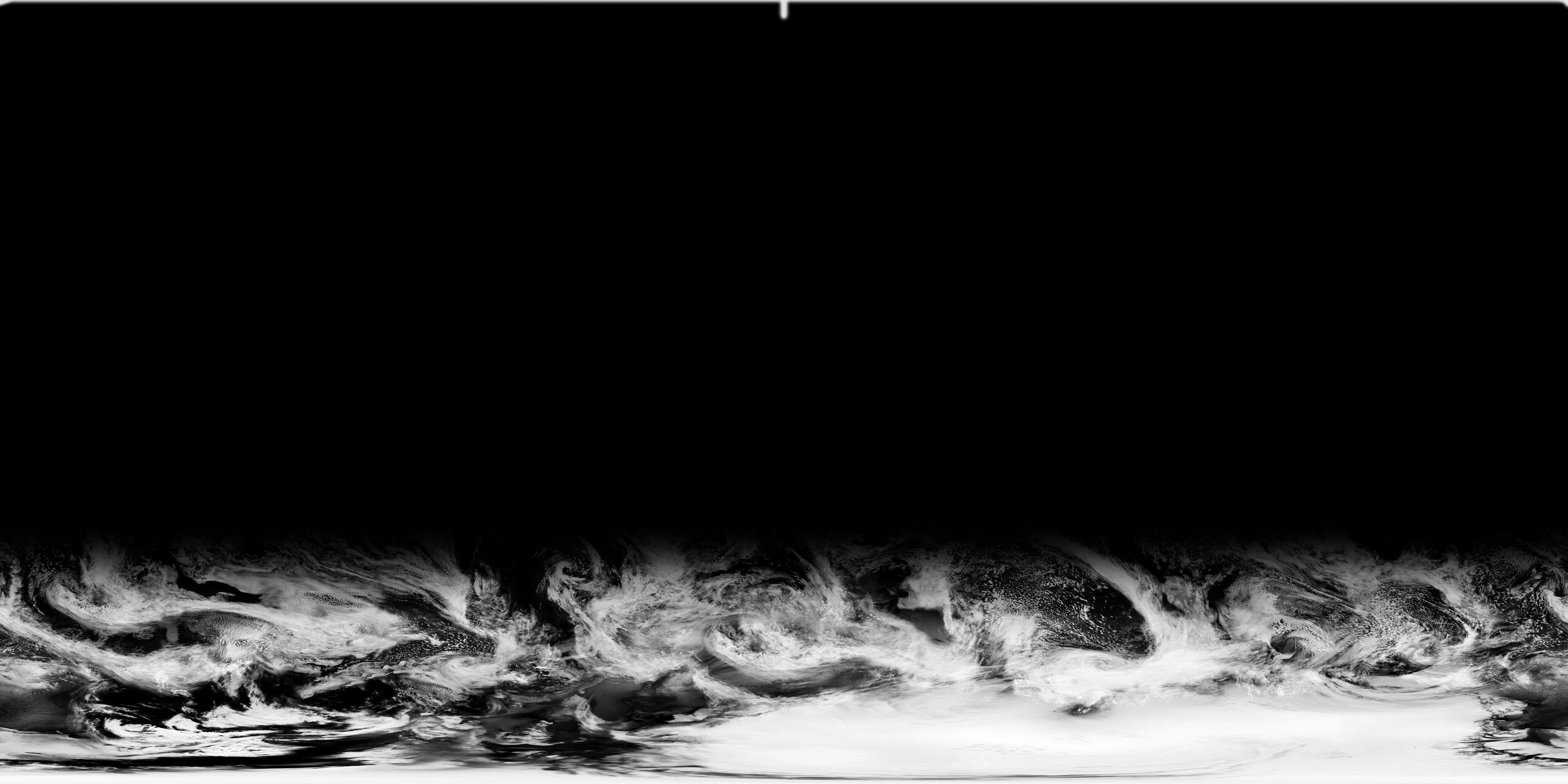
A greyscale cloud map. Layer this over an image of Earth (and set the blending mode to 'screen' if necessary).
Cloud map image URLs (all resolutions)
These URLs are for the latest images:You can download historic images from this project's Releases, or
https://github.com/matteason/daily-cloud-maps/releases/download/[YYYY-MM-DD]/[FILENAME] - for example,
https://github.com/matteason/daily-cloud-maps/releases/download/2022-07-27/8192x4096-clouds.jpg

The same as above, but as a PNG with alpha transparency (the preview above may not be visible if you use light mode)
Cloud map (alpha) image URLs (all resolutions)
These URLs are for the latest images:- 1024x512 cloud map (alpha)
- 2048x1024 cloud map (alpha)
- 4096x2048 cloud map (alpha)
- 8192x4096 cloud map (alpha)
You can download historic images from this project's Releases, or
https://github.com/matteason/daily-cloud-maps/releases/download/[YYYY-MM-DD]/[FILENAME] - for example,
https://github.com/matteason/daily-cloud-maps/releases/download/2022-07-27/8192x4096-clouds-alpha.png
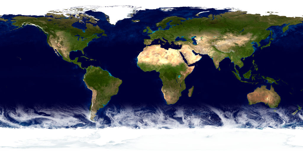
The cloud map overlaid on NASA's The Blue Marble: Land Surface, Ocean Color and Sea Ice image.
Earth with clouds (day) image URLs (all resolutions)
These URLs are for the latest images:- 1024x512 Earth with clouds (day)
- 2048x1024 Earth with clouds (day)
- 4096x2048 Earth with clouds (day)
- 8192x4096 Earth with clouds (day)
You can download historic images from this project's Releases, or
https://github.com/matteason/daily-cloud-maps/releases/download/[YYYY-MM-DD]/[FILENAME] - for example,
https://github.com/matteason/daily-cloud-maps/releases/download/2022-07-27/8192x4096-earth.jpg

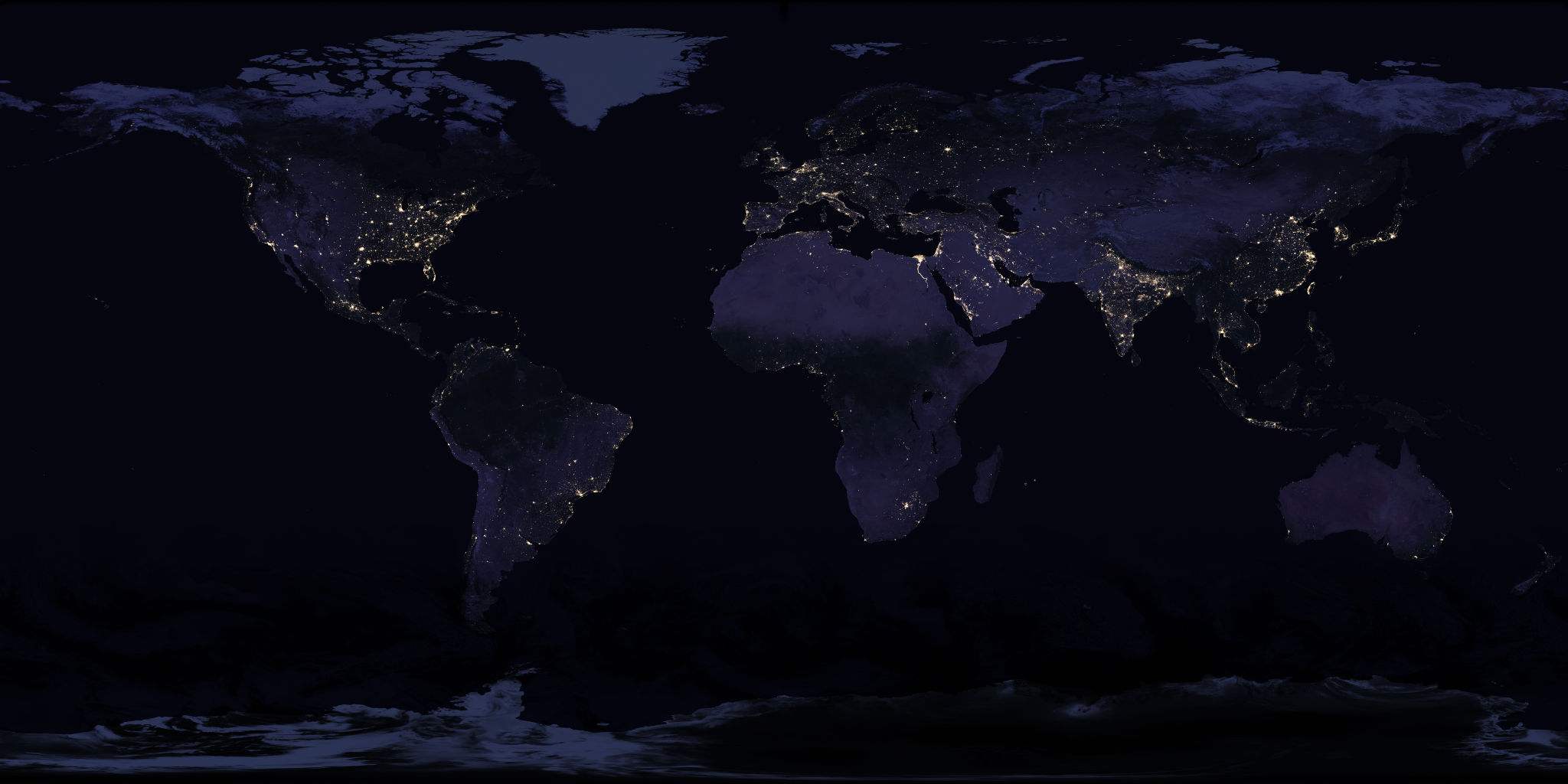
The cloud map overlaid on NASA's Earth at Night image. You can combine this with the day image using some fancy shader magic to create day/night transitions:

Earth with clouds (night) image URLs (all resolutions)
These URLs are for the latest images:- 1024x512 Earth with clouds (night)
- 2048x1024 Earth with clouds (night)
- 4096x2048 Earth with clouds (night)
- 8192x4096 Earth with clouds (night)
You can download historic images from this project's Releases, or
https://github.com/matteason/daily-cloud-maps/releases/download/[YYYY-MM-DD]/[FILENAME] - for example,
https://github.com/matteason/daily-cloud-maps/releases/download/2022-07-27/8192x4096-earth-night.jpg

You can use this specular map to make your model more realistic by only showing specular highlights on bodies of water:

Specular image URLs (all resolutions)
These URLs are for the latest images: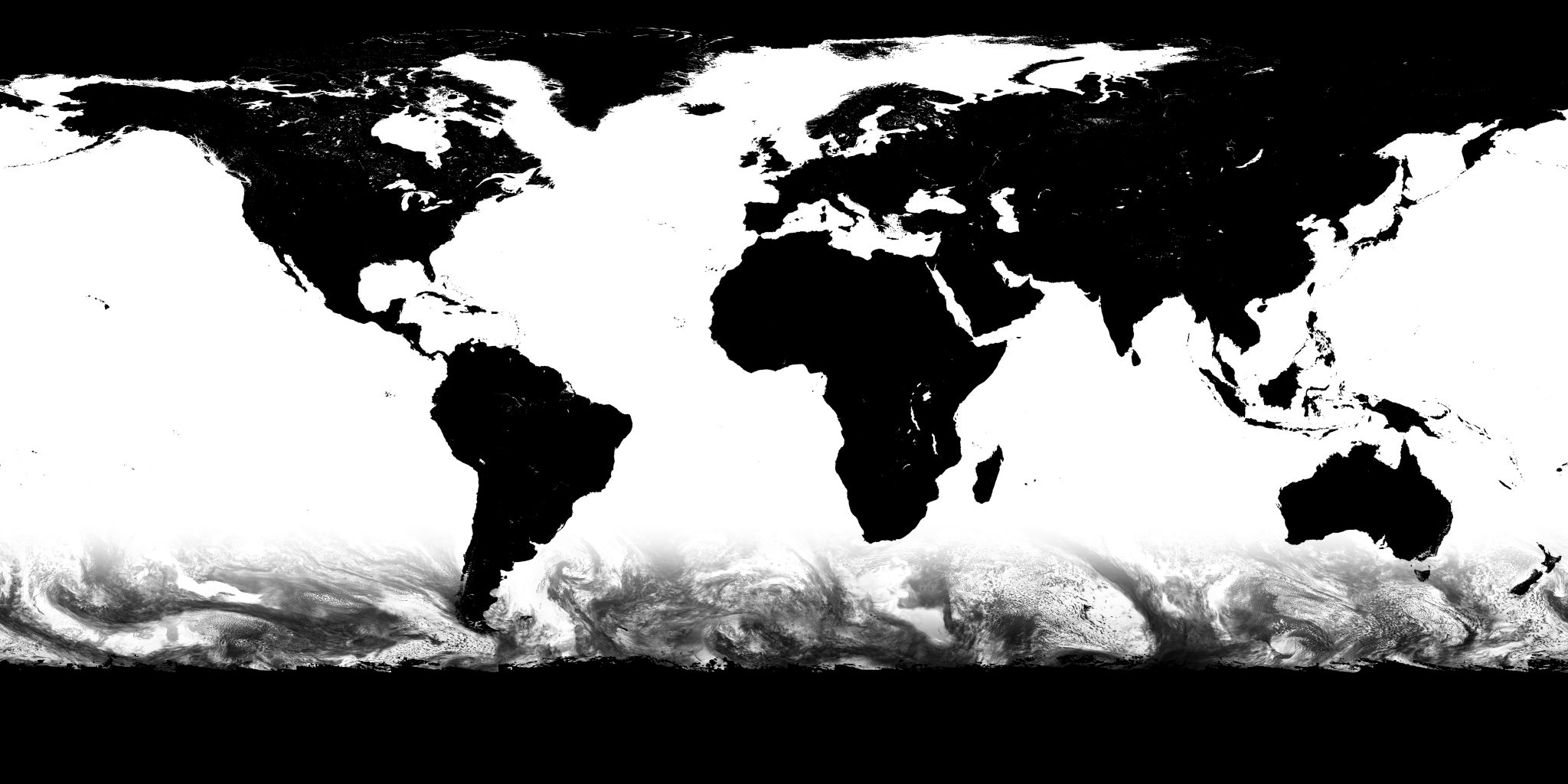
You can download historic images from this project's Releases, or
https://github.com/matteason/daily-cloud-maps/releases/download/[YYYY-MM-DD]/[FILENAME] - for example,
https://github.com/matteason/daily-cloud-maps/releases/download/2022-07-27/8192x4096-specular.jpg
The generated images have some limitations due to the source data.
The satellites tend not to capture the South Pole. To avoid harsh edges, a static image based on Blue Marble Clouds is overlaid on the bottom quarter of the live cloud map. This region isn't very visible on 3D images anyway, and most of the area is covered by the ice cap which makes the clouds even less visible.
Occasionally, the satellites capturing the source data will miss some regions. These areas will appear as square-ish holes without clouds.

Because the satellites orbit the Earth, different regions are captured at different times. Sometimes when adjoining regions are captured at different times, an edge is visible due to the clouds moving between captures.
The source data used for these images is public domain, as works by US government agencies such as NASA aren't protected by copyright.
I've also released the code and images in this repository into the public domain using the CC0 1.0 Universal licence.
I'd appreciate an attribution if you use the code and images, but it's not necessary. Please also acknowledge NASA using the line below (which helpfully also serves as my acknowledgement to them):
I acknowledge the use of imagery provided by services from NASA's Global Imagery Browse Services (GIBS), part of NASA's Earth Observing System Data and Information System (EOSDIS).
Images are processed with the help of the excellent JIMP image manipulation library.
If you find this project useful, you can support me on Ko-Fi:
These cloud maps are generated using two NASA data sources, accessed via the GIBS API: 'Clear Sky Confidence' and 'Corrected Reflectance (True Color)', both captured by NOAA-20 / VIIRS. You can view these data layers on the NASA Worldview visualiser.
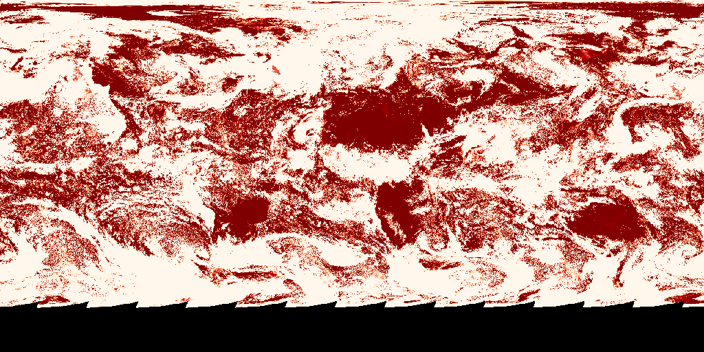

You may be wondering why you can't just use the true colour image directly - and you can, but because the satellites capture the earth in vertical strips, you end up with multiple specular reflections on the sea:

So we take the clear sky confidence and use it to mask the true colour image pixel-by-pixel by taking the confidence map pixel value, converting it to a confidence from 0.0 to 1.0 (how likely is it that the Earth is obscured by clouds?) and multiplying the pixel value of the true-colour image by that confidence. This means we retain the details from the true-colour image in the generated map. The result is then converted to greyscale to remove any residual colour from land or sea showing through the clouds.
